Porphyry Cu - Detecting copper-rich mineralization at depth and under-cover
Rio Tinto - Karaganda Region, Kazakhstan - DasVision 3D IP
Locating high copper concentrations in Porphyry Cu deposits can be challenging due to their extensive, deep-seated, and disseminated nature. Often, the geological conditions and physical properties of the ore body are not distinct or easily distinguishable from the surrounding rocks. The Karaganda Region hosts a porphyry Cu-Mo system that is in the southern part of Torau river valley. There is a silica cap which is evidence of a porphyry system. However, the mineralized zones encountered in the historic boreholes appeared to be structurally controlled and could be epithermal veins or breccia overshoots coming off a much more deeply buried system. Tectonically, it is in the corridor of a major sub-meridional fault.
While the sulphide-rich parts of many porphyry systems contain little or no copper, the mapping of its physical properties can help in defining drillhole targets for a better understanding of their economic potential. The use of Induced Polarization (IP) / Resistivity techniques is proven to be most effective in such context.

Pribrezhniy 3D IP Survey - Current injection points and receiver locations.
Our solution – DasVision 3D IP using 200 m dipoles
The success of 3D IP surveying lies on the combination of electrode configuration, quality of the acquisition, instruments used, inversion, and geological understanding of the target. Abitibi Geophysics’ DasVision is an independant distributed array survey system that allows for investigation of greater than 1 km while retaining good resolution. The dual-dipole receivers are not connected to each other and can be located to avoid natural and man-made obstacles.
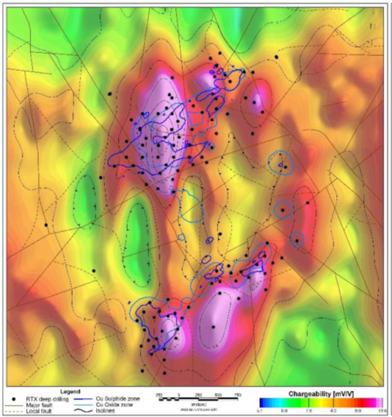
Rio Tinto’s geophysical campaign over the Pribrezhniy copper porphyry system in the Karaganda region included a DasVision 3D IP survey, using 60 Iris V-FullWaver receivers laid out with a 600 m x 600 m mesh. Each receiver had two orthogonal 200 m dipoles. Current was injected between and surrounding the receiver mesh at 200 m intervals and into multiple long bipoles across and around the block of receivers. The data were inverted using the long bipoles for depth control. The DasVision 3D chargeability grid matched and extended the historical copper anomaly to depths of over 500 m. DasVision provided a greater penetration depth than conventional dipole-dipole surveys would, while successfully increasing target resolution.

200 m depth slice chargeability grid from 3D DasVision survey. ©Kumar et al, Rio Tinto Kazakhstan, 2023.
Abitibi Geophysics would like to thank Rio Tinto Exploration Kazakhstan for permission to show these data.


