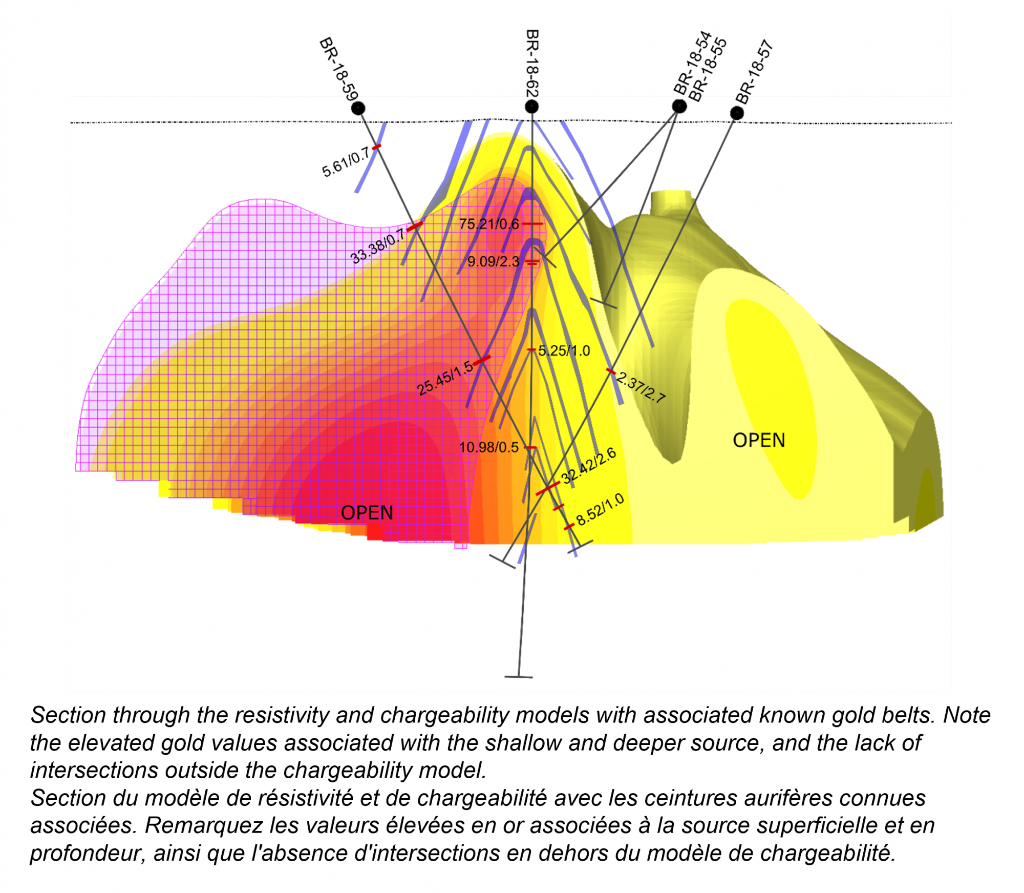
Orogenic Gold Deposits, tracing the extent of mineralisation from a 3D chargeability and resistivity model
Signal Gold Corp – Goldboro Project, Guysborough, Canada
The Goldboro property is located on the eastern shore of Nova Scotia, Canada. East-west trending anticlinal structures composed of interbedded meta-sedimentary rocks including greywacke, arenite, siltstones, and argillite which host the Goldboro deposit and are suspected of hosting further gold mineralization between the Goldboro Deposit and the past producing Dolliver Mountain Gold Mine. The apex of the anticline and surrounding axial zone are the most intensely deformed part of the fold, and where the known gold belts are concentrated. The mineralization is characterized by visible gold and accumulations of sulfide-rich minerals, such as arsenopyrite, pyrrhotite, chalcopyrite, pyrite, and galena; it is concentrated in quartz veins, the argillites that host the veins, and in adjacent rocks. Saddle and reef type vein mineralization are common; these structures are bedding parallel and occur in both the apex and limbs of the fold. There are also spur reefs which cut across bedding. The known deposit has been verified to 500 meters depth and remains open down plunge at depth and to the east and west.
Our solution – Resistivity / Induced Polarization (IP) exploration method for deformed turbidite-hosted mineral occurrences
The Goldboro geological setting is detailed and compact. Multiple veins and mineralization geometries may present as chargeable sources of varying intensity with close distributions. The intense deformation and alteration could promote abnormally low or high resistivity concentrated along the central axis and nearby. Exploring such a deposit geophysically requires the ability to see deeply, depict stacked sources and maintain detail.

In 2022 and 2023, Abitibi Geophysics was commissioned to conduct an IP survey using its OreVision ground 2D and 3D IP technology. Our proprietary IP method allowed us to capture the complexity of the anticline, resolving both shallower structures at the apex of the fold and the deeper limbs. The resistivity and chargeability models provide a strong indication of the position of the anticline, and the more localized mineralization itself. These results in tandem provide a detailed look at the structure and mineralogy of the gold belts and suggest an extension of the trend to the west.
Results
Based on the OreVision surveys and follow-up diamond drilling, Signal Gold Inc. discovered continued gold mineralization up to 450 meters to the west of the known deposit and demonstrated that mineralization remains open along strike to the west and at depth. Our IP survey results confirm that this geological trend continues through the historic Dolliver Mountain Gold Mine, extending the strike potential further west by at least 1.4 kilometers.
“The initial phase of the geophysical survey and recent drill results confirmed that the structure, alteration, and gold mineralization associated with the Goldboro Deposit continues to the west and the most recent results demonstrate that the chargeability response associated with the Goldboro Deposit continues through the past producing Dolliver Mountain Gold Mine. The best location to find a gold deposit is next to an existing deposit or in the shadow of a head frame - this opportunity meets those criteria and is associated with a clear and encouraging IP survey.”
Kevin Bullock, President and CEO, Signal Gold Inc.


