Lithium-bearing pegmatites - Target generation from a high-resolution ground gravity survey
Winsome Resources – Cancet Project, Quebec, Canada
The Cancet Project lies within the La Grande River Greenstone Belt, where a significant amount of gold exploration has been completed. This prolific mineral belt hosts Ni-Cu-PGE, massive sulfides, porphyry, disseminated U-Au, and significant iron formations of volcanic origin. The area is almost completely covered by glacial till. An outcrop of white pegmatite was noted during regional mapping in 2009 by MERN, but no follow-up exploration occurred until the property was staked by Winsome Resources (2016) who discovered a spodumene-rich pegmatite hosted within a gabbroic sill, as well as emplaced into ultramafic (peridotite, pyroxenite) rocks.
Our solution – Letting the geology speak
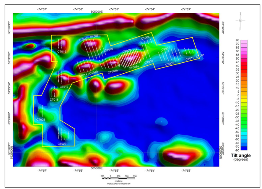
In 2022, Abitibi Geophysics was commissioned to carry out a detailed high-resolution ground gravity survey on the Cancet property. Initially, a high-resolution ground magnetic survey was conducted by Dahrouge Geological in 2017, as it was thought that magnetics could be a valuable targeting tool for identifying trends and corridors that may be prospective for hosting pegmatite.
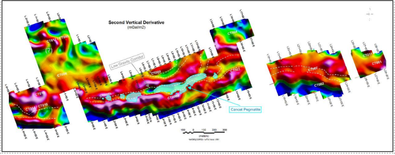
Second vertical derivative of the Bouguer anomaly of the center and eastern blocks including the contour of the Cancet-Pegmatite Showing and the delineated low gravity corridor.
Exploring buried pegmatites presents a challenge as they are considered as geophysically invisible because the physical property contrasts (magnetic susceptibility, density, conductivity, etc.) between pegmatites and their host rocks are often too small to distinguish using geophysical methods. So now what?
The Cancet Pegmatite is strongly associated with ultramafic rocks (peridotite and pyroxenite), and amphibolite, within a wider host gabbro sill. The strong presence of magnetite (largely in the peridotite) provides a strong contrasting magnetic signature to the gabbro. The 2017 ground magnetic survey further delineated this signature and appears to have strengthened the interpreted correlation. Therefore, ground magnetics appears to be an effective exploration tool and should be thoroughly incorporated into ongoing exploration and deposit delineation drill programs.
Ground gravity can also play a key role in mapping spodumene-bearing pegmatite dikes, given the large density contrast between the mafic-ultramafic rocks and the pegmatites. The gravity signature of this pegmatite model should result into a distinctive negative gravity anomaly (low gravity lineament) if the dyke/sill-like mineralized pegmatites are of sufficient width.
 Planned gravity lines over the magnetic targets.
Results
High resolution ground gravity data interpretation can lead to a better understanding of the geometry and possible extension of the Cancet-Pegmatite. This geophysical method provided an initial geologic framework and important information to guide the drilling and other exploration work. Interpretation of the ground gravity data successfully mapped a low gravity corridor which coincides perfectly with the contour of the Cancet pegmatite suggesting potential extension beyond the known deposit.

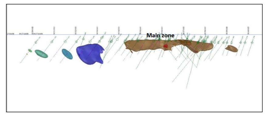
Vertical section showing the mapped pegmatite from drilling.
What our client thinks about the services.
“We were impressed to see how well the buried Cancet orebody can be traced in the ground gravity data. We are very excited to have identified over 1,800m of prospective strike which increases the Cancet exploration target footprint by over 250%.... The use of geophysics is unconventional for pegmatite exploration, but it is the natural strategy in areas where basement rocks are hidden by shallow cover and where systematic mapping and sampling fails.”
Chris Evans M. Eng. Sc., Managing Director - Winsome Resources Ltd.


