Near-surface seismic
Near-surface seismic - Powerful data for geotechnical problem-solving.
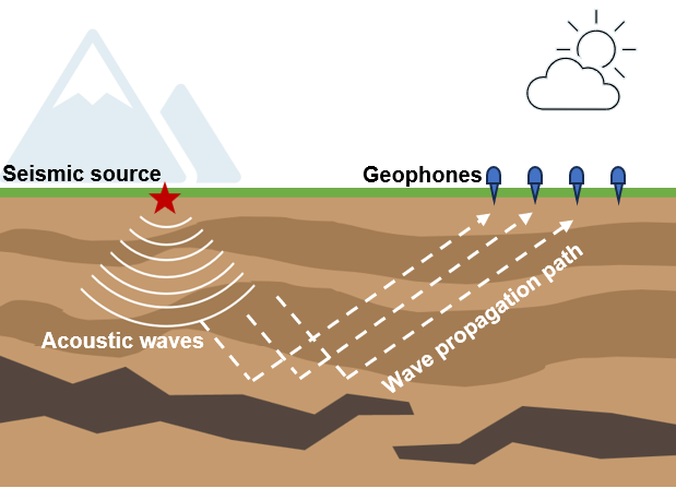
Near-surface seismic surveying offers a detailed understanding of near-surface properties. One of the key benefits is the capability to map subsurface formations and identify irregularities without the necessity for extensive drilling or digging. This cost-effective approach minimizes site disruption, lessens environmental footprint, and conserves both time and resources. It also equips geotechnical engineers with the necessary data for a thorough comprehension of the soil and rock characteristics, pinpointing potential hazards, and formulating effective solutions. This makes near-surface seismic surveying an indispensable tool in the field of geotechnical engineering.
Near-surface seismic data can be useful in numerous applications, such as:
-
Site characterization: Defining soil types, density variations, and layer thicknesses for site assessments and construction planning.
-
Geological structure: Identifying faults, folds, or layers for hazard assessments.
-
Depth profiling: Determining depths to bedrock and soil layers is essential for foundation design or resource exploration.
-
Fluid detection: Assessing groundwater conditions, locating potential contamination sources, and identifying hydrocarbon reservoirs.
-
Mapping lithology, geological contacts, or subterranean structures to delineate rock types, or to map karst features or abandoned mines.
-
Integrity assessment: Identifying potential hazards such as karstic sinkholes and ice thickness or evaluating the suitability of dam sites and pipeline crossings.